Tuesday, February 9, 2010

THIS WAS COWBOY COUNTRY!

Monday, February 8 – Travel Day. Heading to Benson, AZ for a couple of days. We are heading to Texas but are trying to drag our feet and enjoy this great Arizona weather for a few more days. We're staying in Benson I-10 RV Park. We stayed here about a month ago on our way West. We hope to see some sights in Tucson. Took a drive around Benson. Founded in 1880 prior to Arizona’s mining boom, Benson developed as a stopping point for the Butterfield Overland Stage mail delivery route.  Soon thereafter, the Southern Pacific Railroad came into Benson and continued to serve the area until 1997, when the line was purchased by Union Pacific Railroad. 

We did find the Escapee SKP (Co-op) Park...Saguaro. A very nice park. I can't explain why most of the Escapee Parks we see are much nicer than Days End at Livingston, TX, the National Headquarters' Park. I really think they need to improve that park!

Tuesday, February 9 – Headed out early to see Bisbee, AZ. It is located high in the Mule Mountains about 20 miles from the Mexican border.


drive-to-bisbee


valley

More pictures of our drive to Bisbee.

Bisbee, 90 miles southeast of Tucson, is the picturesque county seat of historic Cochise County. The community was founded in 1880 and named after Judge DeWitt Bisbee, a financial backer of the Copper Queen Mine.

The town was amazing. It was named by Frommer's Travel magazine as one on the “coolest small towns in America.” Bisbee is known as the “Queen of the Copper Camps.” It is a former mining town with a HUGE open pit copper mine. In the late 1800's, the mine produced 8 billion pounds of copper. The pit was so large they had to re-route the highway. The mine is no longer in production.

2


3

Many of its Victorian buildings are now homes, antique stores, galleries, fine cafe's and restaurants. We really loved walking around town and enjoying the narrow streets and homes built on the sides of the mountains.


houses-9


houses-5

downtown

bulding

We visited the famous Copper Queen Hotel. It is the oldest continually running Hotel in the state of Arizona. Historically registered at 105 years old. Very pretty inside.

stairs


sitting-room

We did drive up a VERY narrow road to see some houses....I couldn't believe it handled two-way traffic. Lucky we didn't meet an upcoming car! This was one of our favorite site seeing trips of our time on the road.

narrow-street-2

From Bisbee we headed to Tombstone. This unfortunately, was one of my biggest disappointments so far on our journey. Very commercialized! It looked very “Disneylandish” Everything had one purpose.....make money.

"The Town too Tough to Die," Tombstone was perhaps the most renowned of Arizona's old mining camps. When Ed Schieffelin came to Camp Huachuca with a party of soldiers and left the fort to prospect, his comrades told him that he'd find his tombstone rather than silver. Thus, in 1877 Schieffelin named his first claim the Tombstone, and rumors of rich strikes made a boomtown of the settlement that adopted this name.

Tombstone is the site of the famous gun fight at the OK Corral. The Gunfight at the O.K. Corral was a gunfight that occurred at about 3 P.M. on Wednesday, October 26, 1881, in Tombstone. Although only three men were killed during the gunfight, it is generally regarded as the most famous gunfight in the history of the Old West. The combatants were Virgil,Wyatt, Morgan Earp along with "Doc" Holliday versus Ike and Billy Clanton, Tom and Frank Mclaury, and Billy Claiborne. The shootout was essentially the culmination of a feud between the Earps who represented "law and order" in this lawless boomtown, such as it was, and the gang known as the Cowboys, a loose association of cattle rustlers, gunslingers, and other hard men. The Clantons, McLaurys, and Billy Claibourne were part of this faction. Given the nature of the town and the harshness of the Earps, there was considerable sympathy for the Cowboys. The shootout took place at point-blank range and lasted less than thirty seconds. Ike Clanton decided not to fight and left the scene, thus surviving. Billy Clanton and the McLaurys succumbed, the most damage being done by Doc Holliday's shotgun. (A shotgun is extremely lethal at short range.) Doc, Virgil, and Morgan were each shot but none hurt severely. Only Wyatt walked away unscathed.

In the 1880s, the Bird Cage Theater was not only a theater, but also served as a saloon, gambling hall and reportedly even a brothel. Legend has it that 26 people were killed in The Bird Cage during it reputed eight years as one of the wildest and meanest places in Tombstone, Arizona. Over a 120 bullet holes remain in the building . The ladies of the night, plied their trade in cribs suspended from the ceiling in the building. There  are 14 cribs which line the sides of the gambling hall in the Bird Cage Theatre, 7 on each side of the room. The ladies would close the drapes to entertain their clients.
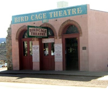
bird-cage


side-walk
stage-coach-2

We did enjoy Boothill. Tombstone's famous "Boothill Graveyard" was originally plotted in 1878 and was first named "The Tombstone Cemetery". There was a section for all the Chinese and another area for the Jewish. It is believed some 300 persons in all were buried here. It was common for bodies to be found in various parts in and outside of town, with no one ever being able to identify them, and they were interred with no markings, or as "unknown". This is the burial site of many gun fight losers!

graves-2

OK Corral shoot out.
billy-clanton


lynched


china-mary

Thanks for stopping by. Hope to see y’all again real soon.

Sunday, February 7, 2010

CLEVELAND INDIANS……GOOOOO TRIBE!

Saturday, February 6 – Sightseeing in the Phoenix area today. Goodyear is a new and thriving area. Everything appears new. Our first stop was Goodyear, AZ home of the Cleveland Indians Spring Training.

sign


paul

This is one of Marsha's bucketlist Items! When she found out the gates were open, she just about ran in. We planned on being here to see a few games, but we'll have to do that in the future due to my back problems. Marsha wants Lynne, Stephanie, Pam and all her other Indian friends to know that it is as awesome as you all think!

me-dug-out

The Indians' facility is outstanding. We really enjoyed walking through the stadium. We even stopped and bought t-shirts.

stadium


stadium-5

Of course there are many more pictures of the stadium here.

There was a small community festival going on outside the stadium. We learned that this gathering happens at every game. We were walking through enjoying the booths when one of the girls working a booth asked me why I was wearing a Texas t-shirt and not an Indians shirt. Marsha and I turned to speak with her when she said, “Oh my gosh, Mr. & Mrs. Weaver!” It was Allie Flath, a girl that graduated from high school with our oldest daughter, Kelly. They had played soccer together for many years! What a SMALL WORLD! She had moved to Scottsdale in October.

While at the festival we had to eat. We had some super spicy tamales at Molly’s Tamales…ummmmm!

tamales


Then Paul has got a sweet tooth for fry bread. Goooooood.

fry-bread


Next door to the Indians stadium is City Center Airpark project, a 401 acre master planned mixed-use project. It has over a mile of direct frontage with the existing Phoenix-Goodyear Airport, a general aviation airport that has the third longest civilian runway in Arizona. There is a section for airplane storage facility. These planes are parked in the dry desert environment so they don't suffer from exposure to the elements. They are in storage until needed or sold.

planes-mt.


planes


Next it was a drive through Phoenix toward Mesa. That was a mistake....a huge traffic jam in a construction zone. It is often said that Phoenix is one huge construction site due to its rapid growth. We moved very slowly for over an hour. We had hoped to visit my nephew Dave and his family but failed to make connections. We did stop at Camping World RV to purchase a couple of folding tables. We are looking for outdoor chairs but can't seem to find the “right ones.”

We returned to the campground so Marsha could take Bella for her walk. We then chilled for the rest of the evening. We did enjoy watching the severe winter storm hitting our former home – Ohio. What a difference from the beautiful sunny summer weather here in Arizona! Oh sorry all you Ohioans.

Thanks for stopping by.

Saturday, February 6, 2010

FUN IN THE VALLEY

Wednesday, February 3 – Drove through Desert Palms. What a beautiful upscale community! Nestled in the foothills of the mountains just east of Palm Springs.


wall-decoration

neighborhood

Late in the afternoon, we drove over to have dinner with some new friends we met in Quartzsite. Jeri & Terri Williams and Janice & Jerry Hyder. They are in a Thousand Trails membership campground about ten minutes from where we are staying. We enjoyed a steak dinner and shared memories with each other.

jeri-terry-janice-jerry-pau

As we were getting ready to eat, we had a visitor. We have never seen a Roadrunner close up. This is the male. The female came along later but it was too dark to take her picture.

roadrunner roadrunner-2

Indio is surrounded by beautiful mountain ranges. It snowed at the top each day. But we were warm with an average of 73 each day.

mts.-and-snow-2

Here is some pictures of the Fantasy Springs Casino and our parking spot.

casino

casino-flowers-2
casino-parking

We ended a great day with another beautiful sunset.

sunset

Thursday, February 4 –
Drove to Joshua Tree National Park today. It was a pretty long climb up the mountains near Palm Springs.


drive-to-Joshua-tree-2

We passed THOUSANDS of windmills used to produce electricity. It was amazing.

mts.-in-background-windmill

close-up

More pictures of the windmills.

Soon we arrived at Joshua Tree. We stopped at the visitors center to pickup a map and headed into this desert park.

The Joshua tree is a giant member of the lily family. It provides a good indicator that you are in the Mojave Desert. The National Park is located in the Little San Bernardino Mountains. Years ago, the Joshua tree was recognized by Native Americans for its useful properties; tough leaves were worked into baskets and sandals, and raw or roasted flower buds and seeds made a healthy addition to the diet. The tallest tree in the ark looms a whopping forty feet high. It is estimated to be about 300 years old! They do not have growth rings like an oak or pine. This makes aging difficult, but you can divide the height of a Joshua tree by the average annual growth of one-half inch to get a rough estimate.

joshua-trees-lots

According to legend, Mormon pioneers considered the limbs of the Joshua trees to resemble the upstretched arms of Joshua leading them to the promised land. Some trees grow like straight stalks; these trees have never bloomed—which is why they are branchless.


single-palm

Golly, you can't believe the huge boulders and strange rock formations. The rock formations of Joshua Tree National Park were formed 100 million years ago from the cooling of magma beneath the surface. The park is well laid out so you can drive into the beautiful mountains and around the rocks.


rocks-7

rocks-and-us-close-up

rocks-10

More pictures of Joshua Tree National Park.

With the recent rains the desert was showing signs of new life. We enjoyed some time in the Cholla Cactus Garden. The species of Cholla that grows in the garden is scientifically named Opuntia bigelovii, but often called Teddy Bear Cholla or Jumping Cholla. The latter name was derived from the way the joints break off — very easily after being only slightly bumped or disturbed. Watch the ground carefully as you walk for these stray bits! New cactus start growing from the broken-off joints, and the garden continues to grow and renew itself. The cactus were spouting new growth and there was a slight green tinge to the country side.

group-2

Jumpers
jumpers


paul


Getting ready to flower
flowers-2

More Cholla pictures.

As we drove through the park, we were surprised to learn that the San Andreas Fault runs through the Park. Joshua Tree is crisscrossed with hundreds of faults, and is a great place to see raw rocks and the effects of earthquakes. The famous San Andreas Fault bounds the south side of the park, and can be observed from Keys View.


fault-great-pic 

paul-and-me

We made a new friend at the Fault.

chimpmunk

More pictures of the Fault.


We spent the whole day driving in the park. There are fifty some miles of road, and I think we drove most of them. We exited the park near I-10 and needed only drive down the 10 mile mountain pass to our boondocking site at the casino.

Later that night we returned to the casino to return some of the meager winnings we walked away with the other day. All-in-all, we broke about even.

Friday, February 5 – Travel Day. Drove about 4 hours and a little over 200 miles to Buckeye, AZ which is thirty miles West of Phoenix. We are staying at Leaf Verde RV Park. It sound like we are near a military base....jet fighters fly pretty low and pretty often overhead.

Hope you enjoyed the blog. Stop back again, please.