Tuesday, September 24, 2013

MOVING ON TO CORTEZ, COLORADO

Monday, September 23 – We are S-P-O-I-L-E-D. We had to go three whole days without Internet or cell phone. We both thought we were just about going to die. Thank goodness for Direct TV.

We headed out of Utah this morning and spread ourselves in four states. We visited the Four Corners National Park. Again, an Indian Park, so the America the Beautiful pass was not accepted. A $3/person admission was charged....not bad. We spread our limbs into four different states ....Arizona, Colorado, Utah, and New Mexico. Yeah, we know this is just a symbolic marker....guess GPS has found the actual site is off by 2.5 miles.

four corners sign

four corners

From there we headed to our campground for the next three or four days at LaMesa RV Park in Cortez, Colorado. A Passport America RV park so we can stay two days at half price. We are in site #27, a full-hookup, 50 amp, pull-through site.

Site 27

site 27

Looking right.
site 27

Looking left.
site 27

We were SHOCKED to see SNOW in the nearby mountains. What's with that? We checked the local weather forecast and much to our surprise they are forecasting a low of 35 degrees tonight......YIKES!!!

La Plata Mountains
La Plata

After getting set-up in our site, we headed about 45 miles east to Durango, CO. We visited this area about 30 years ago to ride the Silverton-Durango Railroad. We're not riding the train this time, but it was fun to see how the city changed. It's much bigger! Not a sleepy mountain town any more. We walked around the historic district for about an hour enjoying a little window shopping.

Historic Strater Hotel built in 1891Strater Hotel

Strater Hotel

General Palmer Hotel built in 1898palmer hotel

Old downtown.
downtown

On the way back to Cortez, we stopped at a home where a guy sells cabin style furniture made out of Aspen wood. Paul talked to him awhile and was rewarded with several pieces of Aspen wood for carving. Cool!

There are signs along the road cautioning drivers to watch for Elk and Deer.

Elk

With our campground having Internet and good Verizon phone signal, we returned to catch up on our computer stuff, call family, and do some grocery shopping. Paul washed the red canyon dust off the truck too! It's good to be back in civilization again. Gotta' love the electronic 21st century......LOL

TIRE QUESTION UPDATE: Several inquiring minds have asked what tires we have on the 5th wheel after our two problems. We currently have Goodyear Marathon ST 235/80 R16 with Load Range E and a maximum inflation of 80 PSI.

Paul was running them at about 75 PSI and found he should always keep them inflated to the maximum 80 PSI. Not sure if that was the problem. Also was told that long travel days in near 100 degree temperatures prior to the blowout could have been the cause.

Regardless, Paul is researching tires and even the possibility of going to larger rims. Any suggestions would be appreciated. Email Paul directly: pweaver123@gmail.com.

Thanks for stopping by. Hope to see y'all back real soon. Have a great day!

Monday, September 23, 2013

A BREATHTAKING RIDE UP AND DOWN

Sunday, September 22 – We visited three sights today beginning with the Moki Dugway. The breathtaking ride up the Moki Dugway is an experience not soon forgotten. Stunning views open from the Dugway as it winds its way up an 10% grade, 1200 feet from Cedar Mesa to the Valley of the Gods.

Moki Dugway

The Dugway got its name from the ruts DUG into the trail so wagon trains climbing the mountain could put their wheels in the ruts and not slide off the side of the mountain. Can't imagine horse-pulled wagons climbing this grade. The road does have a “wash board” texture. Why does this happen on dirt roads? Any ideas?

Up we go.
Moki Dugway

One of the many switchbacks.Moki Dugway

Moki Dugway

This guy is nuts doing this drive with this load!
Moki Dugway

At the top of the mesa, a road leads west five miles to Muley Point. It provides a wonderful view of the valley below. We could see the Four Corners region (The spot where NM, AZ, UT, and CO meet.), to the east lies Sleeping Ute Mountains near Cortez, CO, to the southeast is Shiprock, AZ and to the southwest are the Corrizo Mountains in New Mexico.

Muley point

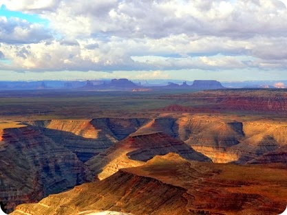
Our third stop was Goosenecks State Park. This is one of those sights Paul has been wanting to see for sometime. We were here about 30 years ago, and it's a memory that stuck in Paul's mind. It's an awesome view of the San Juan River meandering through the red rock over a 1000 feet below the overlook.

Goosnecks SP

We walked along the rim (no guard rails, so be careful and don't trip) to take in several different views and to get some pictures of the river curving below.

Goosnecks SP

We then drove out the path along the canyon rim to check out some boondocking (camping without hookups) sights. We are considering moving up here for a night or two if the weather cooperates. Unfortunately, the weather guesser is calling for rain, high winds, and possible snow or hail. That would make camping on the rim pretty scary and in our minds a No No!

Vicious wildlife is everywhere.Goosnecks SP

We intended to continue on to Natural Bridges National Monument, but the skies were looking threatening (heavy thunderstorms predicted for this afternoon). Marsha was getting nervous about descending Moki Dugway during or after a heavy rain, so we decided to return to the campground and put off visiting the Bridges until tomorrow. That will require another pass through the Dugway.....don't remind Marsha!

We will be back with the living tomorrow. Headed for Cortez, CO. The campground assures us that we will have WIFI and cell phone…yipppppeeeee!

Thanks for stopping by. Hope to see y'all back real soon. Have a great day!

VALLEY OF THE GODS

Saturday, September 21 – We hit the trail again early this morning to drive through the Valley of the Gods.

Valley of the Gods

Now this is more like it! Much better than Monument Valley. In our minds you can skip Monument Valley and instead enjoy the Valley of the Gods.

The Valley is administered by Bureau of Land Management (BLM), and they do a terrific job maintaining the road through the area. The 17-mile loop road is a graded gravel and clay surface road that has a few sharp turns and crosses several washes. It is suitable for most passenger cars when the road conditions are dry. Driving time is approximately two hours.

road conditions

The beautiful Cedar Mesa sandstone monoliths, pinnacles, and other geological features of this amazing area along with the accessibility make it far superior to Monument Valley, in our opinion.

Valley of the Gods

During the drive through the valley you see a number monoliths which have been given local names. A guide is available to help identify each feature, but it is equally fun to name them yourself, depending on what you think they look like.

Seven Sailors
Seven Sailors

Hen sitting on the butte.
 setting hen butte

The next one is called Balanced Rock and Lady in a Tub. See her little toes sticking up.

balanced rock/lady in a tub

Marsha named this one Locomotive. See the moon. This is two days after the Harvest moon.

locomotive

Before things begin getting hot and hazy, we recommend you head to the Valley early. That provides the best lighting for viewing and photography.

Fragile foliage.
foliage

foliage

We were permitted to hike to any landmark of our choosing.

Castle Butte.
Castle butte

Being BLM land, you are free to spend the night along the road in beautiful sites found among the rocks. Our 5th wheel is too big to get down the road comfortably.

truck

Thanks for stopping by. Hope to see y'all back real soon. Have a great day!